The location of the landfall was north of Dhamra in Odisha's Bhadrak district and 50 km south of Balasore, close to Bahanaga block, on the coast.

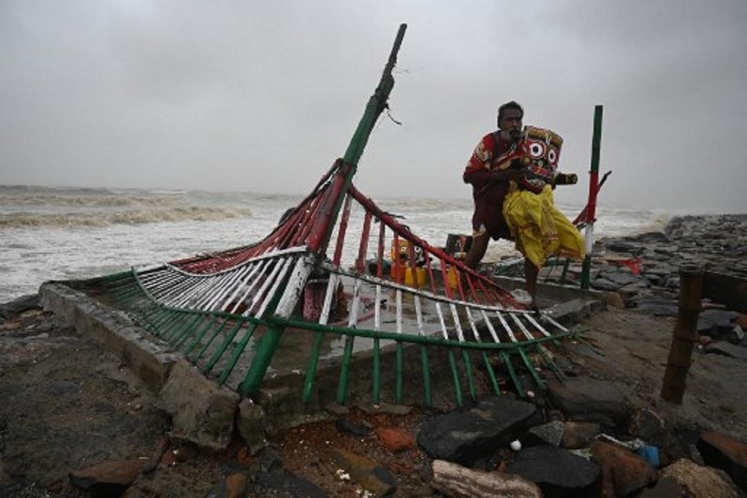
A priest removes an idol of Lord Jagannath from a seafront temple to a safer place, in Balasore district in Odisha. Pic/AFP
Cyclone Yaas pounded the beach towns in north Odisha and neighbouring West Bengal as it hit the coast around 9 am on Wednesday with a wind speed of 130-140 kmph, inundating the low-lying areas amid a storm surge, officials said.
ADVERTISEMENT
The location of the landfall was north of Dhamra in Odisha's Bhadrak district and 50 km south of Balasore, close to Bahanaga block, on the coast, they said.
The wind speed during landfall was at 130-140 kmph, gusting to 155 kmph, as per Doppler radar data.
"The landfall process is likely to be over by 1 pm. The maximum impact will be in Balasore and Bhadrak districts," Odisha's Special Relief Commissioner PK Jena said.
The sea will remain rough till Thursday and the accompanying rain will continue, he said.
The wind will slow down by the evening and the cyclone is likely to leave Odisha for Jharkhand by midnight, Jena said.
Odisha has shifted 5.8 lakh people to safer places, while West Bengal has moved 15 lakh people ahead of the cyclone.
Also Read: Cyclone Yaas begins landfall near Dhamra port in Odisha with wind speed of 130-140 kmph
There was no report of any major damage in Odisha though some incidents of trees getting uprooted have taken place, Jena said.
West Bengal Chief Minister Mamata Banerjee said most parts of the state were affected by the cyclone and the rain it brought along.
She urged the people of the state, particularly those in Purba Medinipur, South 24 Parganas, North 24 Parganas, Paschim Medinipur, Howrah, Hooghly, Purulia and Naida, to stay indoors.
"Almost the whole of West Bengal has been flooded. Several embankments have been damaged and seawater entered areas like Sagar and Gosaba in South 24 Parganas, as well as coastal areas like Digha, Shankarpur and Mandarmani in East Midnapore. Low lying areas have been extensively damaged," the chief minister said.
Banerjee, who monitored the situation from the secretariat the entire night, said that the spring tide has added to the woes.
Efforts are being made to evacuate more people from the coastal areas of Digha, she said.
Digha in East Midnapore sharees border with Odisha's Balasore district.
Banerjee said that 70 km of embankments have been damaged in East Midnapore, while in South 24 Parganas, 15 embankments had met a similar fate.
Reports of damage caused due to flooding by river water were received from areas like Joynagar, Basanti, Kultuli, Namkhana in the South 24 Parganas district, she added.
The chief minister said that though there has been no report of any disruption in Kolkata, all flyovers have been shut as a precautionary measure.
"We will keep on monitoring the situation as it may continue for four to six hours after hitting the land," she said.
The West Bengal government has opened a centralised control room at the state secretariat and several small control rooms in the coastal areas.
The maximum wind speed in Digha reached around 90 km per hour. It was 68 kmph at Fraserganj in South 24 Parganas, and in Kolkata, the highest wind speed was recorded at 62 kmph.
In the 24 hours till 8.30 am, Digha received 5.5 cm rainfall, Diamond Harbour got 3.3 cm rainfall, Haldia 3.2 cm rainfall.
Kolkata got 2.24 cm rainfall, Salt Lake received 3.05 cm rains, Contai got 5.42 cm rains and Kalaikunda received 2.2 cm rainfall.
Banerjee said the NDRF, SDRF and at least 2 lakh policemen are working in tandem to tackle Yaas. The Army has also been kept on stand-by and would be deployed, if needed.
Most parts of Odisha also received rains, said Umashankar Dash, a scientist at the Regional Meteorological Centre in Bhubaneswar.
Chandbali in Bhadrak district received 27.3 cm rainfall, the highest amount of rainfall in the last 24 hours in the state, followed by Paradip (19.7 cm), Balasore (5.1 cm) Bhubaneswar (4.9 cm).
The IMD has forecast massive storm surge for some places like Mohanpur in Bhadrak where the seawater may ingress 9 km into the land.
Dash said that surge of 1.5-3.8 metre is likely in the area when the wind speed hits a peak during landfall. The reason behind such a high storm surge is also partially due to full-moon activity.
This story has been sourced from a third party syndicated feed, agencies. Mid-day accepts no responsibility or liability for its dependability, trustworthiness, reliability and data of the text. Mid-day management/mid-day.com reserves the sole right to alter, delete or remove (without notice) the content in its absolute discretion for any reason whatsoever.
 Subscribe today by clicking the link and stay updated with the latest news!" Click here!


