City records second highest single-day July rain in 45 yrs at 375.2mm; highest was recorded in year 2005 when it received 944.2mm rain

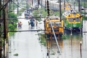
Flooded railway tracks at Kurla station on Tuesday. Pic/Sayyed Sameer Abedi
At 375.2 mm, the city recorded the second highest rainfall on a single day in July in the past 45 years on Monday, according to Indian Meteorological Department (IMD) data, Mumbai. It was the same as recorded in the year 1974. However, the highest single-day July rainfall (944.2mm) was recorded in 2005, when the city faced one of its worst floods. Sources in the IMD said that the intensity of rain would decrease in the next 24 hours but intermittent showers would continue.
ADVERTISEMENT
In the past three years, single-day July rainfall was recorded at 184.3mm, 163.4mm and 115mm respectively. After Santacruz, the areas that received the heaviest rainfall in the city were Powai (371.20mm), Vidyavihar/Borivli (346mm), Andheri (336.20mm) and Kandivli (315mm). The lowest rainfall was recorded in Worli's NSC locality at 67.40mm.
According to IMD's forecast, again on July 5 heavy rainfall is expected in isolated places, which would further decrease on July 6. "Due to active monsoon conditions, the entire Konkan coast is experiencing an intense spell of rainfall. Monsoon remained widespread over the entire North Konkan belt, including Mumbai with heavy to very heavy rainfall over most places," read the update shared by IMD.
It further said that rough to very rough sea conditions (with wind speed reaching 40-50 kmph) would prevail over west central and southwest Arabian Sea. Squally weather conditions would prevail over North Maharashtra coast. Fishermen are advised not to venture into the sea in the next 24 hours.
CAG slams civic body on flood management
The CAG report that the state government tabled on Tuesday said there was a delay of six years in updating the BRIMSTOWAD project because the consultant had not submitted the report till April 2018. It has made several observations in desilting of and widening of nullahs/rivers. They said that of its length of 21.58 km, only 15.849 km could be widened and deepened. The widening of Poisar River fell short by 3 km.
Observations
- Drains affected as flat gradients allow tides to hit them
- Drainage system is heavily silted. Capacity of drains is adequate only for 25mm/hour.
- Discharge points are much below mean sea level
- Storm water drains discharge rainwater directly by gravity through outfalls in absence of floodgates at 42 points. Only three outlets have floodgates which helps in controlling tides only at those points
- Siphons and utility services obstruct drains
- Poor repairs and maintenance of drains when they are punctured by utility service providers
- Poorly placed gullies and their structural stability also poor
— Dharmendra Jore
Catch up on all the latest Crime, National, International and Hatke news here. Also download the new mid-day Android and iOS apps to get latest updates
 Subscribe today by clicking the link and stay updated with the latest news!" Click here!


